 | |||||||||
| Home | A Brief History |
Amusement Park |
Bars & Dance Halls |
Photo Gallery |
Historical Events |
BLYC | Local Restaurant Guide |
Store | Contact Us |
The Refugee Tract
The Refugee Tract (Lands) is located in parts of Franklin, Fairfield, Licking and Perry counties in Central Ohio. This tract extends 42 miles eastward from the Scioto River, along the south line of the United States Military District. The first 30 miles are four and one half miles wide but narrows to three miles wide for the last twelve miles. This tract contains 103,527 acres.
The Continental Congress resolved to grant land to Canadian refugees (April 23, 1783) and to Refugees of Nova Scotia (April 13, 1785), whenever Congress could legally make such grants of land. These refugees had abandoned their settlements and fled to the United States to aid the colonial cause during the Revolutionary War.
The Act of April 7, 1798 provided that the refugees had to have fled prior to July 4, 1776; continued aiding the United States; and did not return to reside in the dominions of the King of Great Britain prior to November 25, 1783. It also provided that the bounty land could be claimed by widows and heirs of all such persons, if they died within the United States or in colonial service during the Revolutionary War.
The Act of February 18, 1801, established the boundaries of the Refugee Tract and named the claimants and the quantity of land which they were entitled. Additional claimants were named in the acts of April 23, 1812. By these Acts, 67 claimants received 58,080 acres, most of which were in 320, 640, 960, 1,280, and 2,240 acre grants.
The Refugee Lands were not set aside until after the regular Federal surveys had progressed to the United States Military District. Therefore, the range, township and section lines and numbers were already established. The townships, being fractional (par-tial) townships, were subdivided into 320-acre lots by halving each full section with a north and south line. A drawing, by lot, determined the location, or locations, of the claimant’s grant.
The Act of April 29, 1816 authorized the remaining 45,447 acres to be sold by the Chillicothe Land Office.
“During the Revolutionary war many of the people of the British provinces in Canada so strongly sympathized with the cause of the American colonies that they were obnoxious to their neighbors, and were ultimately obliged to abandon their homes and property, and seek refuge in the colonies, where some entered the Revolutionary army. The property of such was confiscated, and they became permanent citizens of the United States.
By resolutions passed by Congress, April 23, 1783, and April 13, 1785, the refugees were, “on account of their attachment to the interest of the United States, recommended to the humanity and particular attention of the several States in which they reside,” and informed that, “whenever Congress can consistently reward them by grants of land they will do so, by making such reasonable and adequate provision for them on our public domain as will amply remunerate them.”
On the 17th of April, 1798, Congress progressed to the point of inviting all refugees who were claimants of land to make their claims apparent to the War Department within two years from the date of said action, by “rendering a full and true account of their claims to the bounty of Congress.”
The refugees thereupon made proofs of their respective services, sacrifices and sufferings in consequence of their attachment to the cause of the colonies against the mother country, and when the legal limit had expired, within which proof of claims must be made, the Secretary of War divided the refugees into a number of classes, awarding to the first class 2,240 acres, and to the lowest 160 acres.
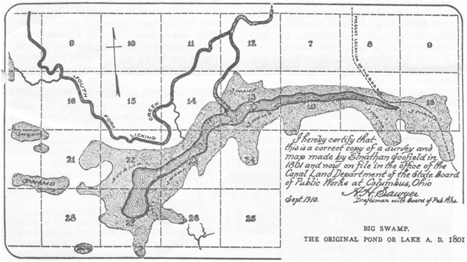
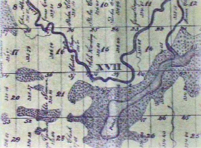
Surveyor Elnathan Schofield found “Big Swamp" ( Buckeye Lake ) with its Pond about mid-way across the Tract. These are shown on a map which he signed and dated 1801 According to this map, the pond in the middle of the swamp was about 5 miles long and had an average width of approximately 1/6 of a mile. Many refugees from northen British colonies were not long in coming to the Tract, to enjoy their rewards and expand their newly won freedom in their adopted country. Some of the shores of young Buckeye Lake were settled by the time Schofield finished his map of the area. About a third of the Tract was settled by 1801. Most of the settlers selected hill sections for their future homes. They avoided the ague ridden Big Swamp region But some were more courageous and perhaps more romantic. They braved mosquitos to be near Big Pond. Among such intrepid settlers were Martha Walker, this family name still graces the Lake’s shore at Walkers Landing and Walkers Honey Creek Park.